Forum sponsored by:

How to make concrete last 2000 years
| Russell Eberhardt | 28/01/2023 10:07:10 |
 2785 forum posts 87 photos | I thought this was an fascinating article: https://arstechnica.com/science/2023/01/ancient-roman-concrete-could-self-heal-thanks-to-hot-mixing-with-quicklime/ Our methods of engineering aren't always better than the ancients! Russell |
| J Hancock | 28/01/2023 12:28:57 |
| 869 forum posts | It is a joy to examine aqueducts the likes of the Pont du Gard , precision stonework with mortar no thicker than a sheet of cardboard between each layer. |
| Russell Eberhardt | 29/01/2023 11:21:26 |
2785 forum posts 87 photos | Posted by J Hancock on 28/01/2023 12:28:57:
It is a joy to examine aqueducts the likes of the Pont du Gard , precision stonework with mortar no thicker than a sheet of cardboard between each layer. Yes, that is a magnificent structure and a great tourist attraction. Near to where we live is the pont-aqueduc d'Ansignan a much smaller version but one that is still serving it's original purpose of supplying irrigation water around the village after nearly 2000 years! I have walked through the tunnel that runs under the water channel and it was completely dry. Russell |
| Alan Johnson 7 | 29/01/2023 12:52:01 |
| 127 forum posts 19 photos | Pont du Gard. Built in about 90AD on schedule and within budget. Who said "What did the Romans do for us!" |
| SillyOldDuffer | 29/01/2023 16:41:01 |
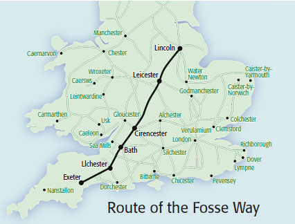
| 10668 forum posts 2415 photos | I think I understand how the Roman's built the Pont du Gard, because it's simple in principle. Once they'd cracked how to build a Roman Arch (semi-circular), the rest is boiler-plate. Big and impressive but not high-end engineering compared with a Victorian elliptical arch or the 1915 Çanakkale Köprüsü, where the centre span of the bridge is over 2km long. To me the surveying that decided the route the aqueduct would take is much more impressive, but I think I know how if might have been done using relatively simple techniques. (Simple when you know how!) Beyond my understanding is how the Romans laid out long straight roads between far distant points. Looking at the Fosseway, we have a straight road connecting Lincoln to Ilchester, with a kink at the end extending to Exeter. On the almost dead straight section lie Leicester, Cirencester and Bath.
Once the bearing between the two ends is established, a straight road is easily laid out by aligning poles. (New front poles are aligned visually with the two poles immediately behind, and the road stays straight with good accuracy.) But how did they establish the bearing in the first place? Today the bearing of Ilchester from Lincoln can be got in a few minutes from a modern map, but the Romans didn't have that sort of map. Or compasses. Short straight stretches of road are easy, but does anyone know how the Romans surveyed a long straight road between very remote locations? It's a long way from Exeter to Lincoln! Building physical objects like the Pont du Gard is amazing enough, but I'm more impressed by the thinking that decided where the aqueduct needed to go relative to a water source and a town, given that difficult country lies between the two. They will have worked out how much it was going to cost too... Dave
Dave |
| Grindstone Cowboy | 29/01/2023 16:46:55 |
| 1160 forum posts 73 photos | SOD - I once went to a lecture by Adam Hart-Davis (remember the "Local Heroes" series on TV?) where he explained how they did it, but unfortunately I can't recall the details now. But they did have a method! Rob |
| Tim Stevens | 29/01/2023 18:39:54 |
 1779 forum posts 1 photos | In my experience Roman roads are straight where you can see from end to end, but only straight-ish elsewhere. Much straighter than the rolling English road made by a rolling English drunkard, though. One fa\ctor was the freedom that the invaders had to put the road where they wanted, in a countryside which was, effectively, empty of roads. And have you considered why the straightness was needed? In flat country, it does give the 'quickest' or shortest route, but was that the only reason? One question is 'How were Roman vehicles steered?, or Have you ever seen a picture of a Roman Wagon with any steerring scheme at all?' I await your answers ... Cheers, Tim |
| Bazyle | 29/01/2023 19:50:22 |
 6956 forum posts 229 photos | Posted by Tim Stevens on 29/01/2023 18:39:54:
in a countryside which was, effectively, empty of roads. No it wasn't. Every single village and town had a network of roads to the others. Just not paved. Alignment of roads to towns was possibly done over long distances using beacons by night and smoke by day. Add to that some understanding of navigation by stars and planets, rising and setting sun or moon and you have a lot of info that we just don't get taught these days. Even more impressive is the early navigation in the Pacific over far greater distances with severe consequences from errors. |
| Nigel Graham 2 | 29/01/2023 21:20:04 |
| 3293 forum posts 112 photos | There were probably very few villages and towns already in England when the Romans arrived. Just scattered Bronze Age settlements with huge areas of forests between them. There were some tracks joining these settlements, often along ridges; but nothing like the Saxon and later density of villages and tracks we see now. A lot of the route-finding might have been by view-points; less effective of course on plains, but many Roman roads do go over hills rather than round them. (As I found when using the Fosse Way from fairly near home to the Warwickshire Exhibition Centre!)
The map Dave shows has Dorchester marked on it. This (as its name suggests) was a Roman settlement only a few miles inland from Weymouth, which was not there then but the Romans did use the Wey estuary as a harbour. These were linked to the Fosse Way somewhere near what is now Yeovil, more likely Ilchester; its route now the A37 then onto Weymouth as the A354. Among the many Roman traces around Dorchester is parts of its water supply. This was an aqueduct taking water from the R. Frome a few miles upstream of the town, and at one point loops round the flanks of a small side-valley now carrying part of the Dorchester bypass. |
| samuel heywood | 29/01/2023 21:44:19 |
| 125 forum posts 14 photos | I remember a family holiday to Hadrians' Wall territory a good few years back~ quite fascinating to us that the Roman mortar was holding up well, the (then) modern repairs starting to fail. As a slight aside, i remember hearing ancient bronze springs had been discovered that 'cycled' better than modern steel ones I I didn't investigate further to see if it really was true so don't quote me on it.
Edited By samuel heywood on 29/01/2023 21:48:15 |
| Tim Stevens | 30/01/2023 14:04:24 |
1779 forum posts 1 photos | I invite Bazyle, and anyone who thinks he is right, to offer evidence of the claim that there were villages and towns all linked by roads, before the Roman invasion. Tim |
| duncan webster | 30/01/2023 14:20:10 |
| 5307 forum posts 83 photos | To set out a dead straight line between 2 distant points the Romans used a device called a groma, a sort of crude theodolite. They set up a line of stations in the right general direction such that each station could see the one in front and the one behind. Then the middle one of three can easily get onto a straight line between its neighbours, and by repeated trial and error the chain of stations gets nearer and nearer to a straight line. If you have every station manned it's probably quite quick. We'd call it iteration nowadays. When they got into mountains they took the line of least resistance. Edited By duncan webster on 30/01/2023 14:21:59 |
| clogs | 30/01/2023 15:34:55 |
| 630 forum posts 12 photos | I tought u just needed 3 poles and a length of string.....not Poles as in Polish.... we cant even build HS2...... |
| Martin Kyte | 30/01/2023 15:53:47 |
 3445 forum posts 62 photos | Maybe the Fosse way evolved. Presumably the Roman Garrisons at Lincoln Leicester and Bath were established before the road was constructed with an amount of marching between centres. After a while the shortest route would have been established by ammending the initial attempts. (ironing out the kinks as it were). The road when it was evemtually constructed maybe then just followed the multitude of footprints between the camps. regards Martin |
| Ady1 | 30/01/2023 15:57:12 |
 6137 forum posts 893 photos | The trams in Edinburgh are about 8 miles long and took 10 years Hadrians wall is 73 miles long and took about 7 years What really impresses me is that there weren't really that many humans about 2000 years ago and yet the Romans built these vast projects across all of Europe and maintained a food supply system to keep it all going Their organising and co-operation skills were 1500 years ahead of anyone else |
| Rod Renshaw | 30/01/2023 16:42:18 |
| 438 forum posts 2 photos | Using the groma was rather like using 3 poles and a length of string, but using a line of sight between plumb lines rather than a length of string. We made gromas at Scout camp many years ago, very low tech, but work well. I suppose the Roman legions had lots of manpower to set up multiple gromas along a stretch of countryside needing a road. Looked at in detail, most Roman roads are a series of straight lines with slight but distinct angles between the straights, often at the tops of hills, which strengthens the lines of sight arguments. I like the idea of straight roads because the Romans could not steer, not seen that theory before. Not sure if it's true though, the Roman road network was a military project intended for the fast movement of troops. And the Roman legions marched. I imagine the Roman commander saying to the "squaddies" "Build a road to over there" and the squaddies just went straight ahead ignoring any pre-existing tracks or settlements or anything smaller than a mountain. I agree with Tim about the absence of a road network before the Romans. Very sparse population, settlements at a distance from each other and mostly self sufficient, almost no wheeled transport of any kind, tracks for any pedestrians and pack animals would take the easiest path which in turn would vary with the season and the weather. Most transport may well have been by water. I seem to remember a friendly contest on one of the archeology programs between a few chaps with a groma and a few with a satnav pole. The task was to set out a Roman marching camp. And I think the men with the groma won. Rod |
| Tim Stevens | 30/01/2023 17:11:26 |
1779 forum posts 1 photos | Rod is right - thanks. Anything that was even slightly heavy went by boat. Look at the placing of the major Roman towns in the UK - almost every one is as far up the river as the boats could get. And of course, that was where a river crossing developed, often a ford to start with, sometimes a floating bridge. Exeter, Dorchester, Winchester, Chichester, Colchester, Gloucester, Chester, Lancaster - and that is just settlements still carrying names based on Roman activity there. Cheers, Tim |
| SillyOldDuffer | 30/01/2023 17:16:23 |
| 10668 forum posts 2415 photos | Posted by duncan webster on 30/01/2023 14:20:10:
To set out a dead straight line between 2 distant points the Romans used a device called a groma, a sort of crude theodolite. They set up a line of stations in the right general direction such that each station could see the one in front and the one behind. Then the middle one of three can easily get onto a straight line between its neighbours, and by repeated trial and error the chain of stations gets nearer and nearer to a straight line. If you have every station manned it's probably quite quick. We'd call it iteration nowadays. When they got into mountains they took the line of least resistance.... The problem with aligning with the Groma and three aligned poles is both are short range instruments. They solve the problem of maintaining a bearing, once the bearing is known but not how to establish the bearing of a distant destination in the first place. Readers are invited to imagine they're a bunch of foreign squaddies who've been plonked down in Lincoln city centre with a Groma and three poles. Their mission is to lay out the line of a road such that the far end arrives in Ilchester, 293km as the crow flies. Without looking anything up on a modern map or Wikipedia, how do you align the first two poles with the destination? Not many people today know where Ilchester is, and I'm hazy about Lincoln! I like the iteration idea though, hard work if that's how they did it. As a Fosse is a ditch, there's a theory that the Fosseway marked the border between civilisation and the Wild West. The purpose of the road is likely to be military. In a few places near Bath, the 19th century road deviates gently to reduce steep slopes because the original Roman road plunges perilously straight down hillsides: that the road ignores geography suggests Infantry marching rather than wheeled trade. Another mystery is which town came first on the road, and why. Exeter is the lowest fordable point on the River Exe, Lincoln was a military strong-point, and Bath a religious leisure centre. My feeling is Ilchester exists because it was the junction between two straights, rather as Swindon became a big town because the village was ideally placed for GWR engine works. More trivia, the word may be derived from the Latin Tri Via, "three roads", a road junction where travellers exchanged news and gossip. Dave |
| Nigel Graham 2 | 30/01/2023 18:11:21 |
| 3293 forum posts 112 photos | Laying out the road's line would have been relatively easy given clear countryside, once they know which way to go, but much of Britain was still heavily forested at the time. So the difficulty would be working through the woods when all you see is the trees. I think they did have wheeled carts, but single-axle. Otherwise they would have used pack-animals. Although military purposes were first and foremost, the Romans and Romano-British would have used the roads for commerce and civilian "traffic" too. ' Ilchester is near Yeovil, about half-way between Bath and Dorchester, and marked the junction between two roads: the Fosse Way's continuation to Exeter, and the road to Dorchester, thence South to Weymouth. The Roman port is thought to have been up-river at Radipole, at least for small vessels, about 3 miles from the estuary. To join Aqvae Svlis to Lindinis (Ilchester) means climbing over Eastern Mendip and a smaller but quite sharp ridge, giving the surveyors long views ahead; but then crossing a wide plain, an inland continuation of the Somerset Levels, to the fort and village established by the Romans on that plain's Southern fringe. West is more plain for some distance then the country becomes mainly hills, but I don't know how the Romans dealt with those. South reaches Dorchester by going over the Dorset Downs (along now, the A37). The A354 from Dorchester goes over the Ridgeway escarpment, and the Romans' steep direct line is now just a track. The modern road deviated via a hairpin-bend, supplanted in turn in 2012 by a new road through a big cutting that might have been deeper and less steep if the LSWR or GWR had not got there first and put a railway tunnel though the hill. So several land-forms for the Romans to cross, with a lot of forest cover and some very moist areas that might have been rich in willow woodland. ' What is notable is how the post-Roman to modern roads sometimes deviate abruptly from their Latinate guides, even where the latter is still evident and the deviation has no obvious topographical advantage. An example is on the A37, coming South from Shepton Mallet. A couple of miles from Ilchester bypass, the road turns very sharply right then wiggles round a bit before regaining the proper Via Lindinis; which runs straight on from the first bend, as a farm track. A second, modern deviation thanks to the bypass makes the original pop out in the village as a surfaced but "No Through Road" lane. |
| Rod Renshaw | 30/01/2023 20:37:41 |
| 438 forum posts 2 photos | The Romans could build mostly straight roads because, as the all conquering heroes they imagined themselves to be, they were not concerned with anything that pre-existed their invasion except the physical geography, and marching troops could manage steep gradients better than any carts of the period. I accept that the roads were used by travellers and traders, but that was after the roads were built. It's not easy to imagine civilians being consulted about the network before it was built. The medieval road layout and routes may well have been influenced by land ownership issues and emerging trade needs, just as the canal and rail networks were influenced in later centuries. I accept the detailed posts about the geography above but I sometimes wonder if the Roman roads were built first, in the right general direction, eg" North," and the towns and forts etc grew up alongside the roads. So, perhaps the problem of how they built the road from town to town does not really exist at all. Remember that before the Romans came there were only small settlements, of little interest to Romans, to them the land was all much the same, effectively a blank canvas, with a few tribes wandering about. Imagine the Roman commander coming ashore at Kent (or wherever) He does not need to build a road to Ilchester ( which does not yet exist) but rather wants to conquer the tribes to the North who he has heard of but does not really know the location of. He tells his squaddies "Build a road in a Northerly direction and we will find them pesky Brits." And as the road is built the army builds way-stations for the troops and the ones in good locations become towns in due course. Could it have been like that? And if so, there is no need for long distance "navigation." Rod |
Please login to post a reply.
Magazine Locator
Want the latest issue of Model Engineer or Model Engineers' Workshop? Use our magazine locator links to find your nearest stockist!
Sign up to our Newsletter
Sign up to our newsletter and get a free digital issue.
You can unsubscribe at anytime. View our privacy policy at www.mortons.co.uk/privacy
Latest Forum Posts
- *Oct 2023: FORUM MIGRATION TIMELINE*
05/10/2023 07:57:11 - Making ER11 collet chuck
05/10/2023 07:56:24 - What did you do today? 2023
05/10/2023 07:25:01 - Orrery
05/10/2023 06:00:41 - Wera hand-tools
05/10/2023 05:47:07 - New member
05/10/2023 04:40:11 - Problems with external pot on at1 vfd
05/10/2023 00:06:32 - Drain plug
04/10/2023 23:36:17 - digi phase converter for 10 machines.....
04/10/2023 23:13:48 - Winter Storage Of Locomotives
04/10/2023 21:02:11 - More Latest Posts...
- View All Topics
Support Our Partners


Shopping Partners
Subscription Offer

Latest "For Sale" Ads
- Reeves** - Rebuilt Royal Scot by Martin Evans
by John Broughton
£300.00 - BRITANNIA 5" GAUGE James Perrier
by Jon Seabright 1
£2,500.00 - Drill Grinder - for restoration
by Nigel Graham 2
£0.00 - WARCO WM18 MILLING MACHINE
by Alex Chudley
£1,200.00 - MYFORD SUPER 7 LATHE
by Alex Chudley
£2,000.00 - More "For Sale" Ads...
Latest "Wanted" Ads
- D1-3 backplate
by Michael Horley
Price Not Specified - fixed steady for a Colchester bantam mark1 800
by George Jervis
Price Not Specified - lbsc pansy
by JACK SIDEBOTHAM
Price Not Specified - Pratt Burnerd multifit chuck key.
by Tim Riome
Price Not Specified - BANDSAW BLADE WELDER
by HUGH
Price Not Specified - More "Wanted" Ads...
Get In Touch!
Do you want to contact the Model Engineer and Model Engineers' Workshop team?
You can contact us by phone, mail or email about the magazines including becoming a contributor, submitting reader's letters or making queries about articles. You can also get in touch about this website, advertising or other general issues.
Click THIS LINK for full contact details.
For subscription issues please see THIS LINK.
Digital Back Issues


Donate

 Register
 Log-in
Model Engineer Magazine
- Percival Marshall
- M.E. History
- LittleLEC
- M.E. Clock

ME Workshop
- An Adcock
- & Shipley
- Horizontal
- Mill

Subscribe Now
- Great savings
- Delivered to your door

Pre-order your copy!
- Delivered to your doorstep!
- Free UK delivery!
All Forum Topics > The Tea Room > How to make concrete last 2000 years